Overall February was an incredibly cheap month. We did do a fair bit of driving, but we kept our food and phone bill costs super low and did not need to do any major fixes on the RV. Some tour costs at national parks did bring us up a little
Maintenance: Andreas lost another fuel cap while filling up. On the bright side, we now have a tethered one, so it shouldn't happen again! We also bought some oil top keep us topped off between changes and got an oil change (which I don't count towards the running RV total, since any car would need those. It does go into the total trip cost though).
Oil: $21.78
Fuel Cap: $14.06
Oil Change: $58
RV running total: $19,673.70
Fuel: As always, if you're interested, go check out our Fuel log. February was on par November and December in terms of driving, which aren't huge chunks, but do add up.
Gas: $496.08
Propane: $13
Food: $280 - We ate incredibly cheaply this month. Rarely going out and eating fairly low cost groceries.
RV Stickers / Postcards : $33
Lodging: $33.25 - We spent two nights at Big Bend and did some laundry while we were there.
Sightseeing: $68 - We needed to buy entrance tickets for each of our days at Mammoth Cave.
Phone and Internet: $45 - Sticking close to libraries has been keeping this quite low.
Total February travel expenses: $1062.17
##These have not been updated yet.
Total cost of the trip so far: ~$31212.7 - This includes the RV and all of it's repairs, insurance and maintenance
Days Traveling: 171
Cost / person / day : 91.26
Saturday, February 29, 2020
Travel Update 21
This week started out in Big Bend National Park, where we met a few people who we've run into before during our travels. The first was a couple from Virginia in a white travel van. We didn't get a chance to talk to them, but they let us know that they recognized us. The second was a woman from Washington, also in a white travel van, with a bus-like door. We ran into her shortly on the Natches Trace Parkway at the Merryweather Lewis Memorial. It's fun to recognize the same vehicles and to be recognized. Hopefully we'll run into some more repeats along the way and get to share some stories.
From Big Bend, we headed north towards our next two parks. We stopped at another roadside picnic area on the way up. The next day, we went and gathered a bunch of park info from both Guadalupe Mountains and Carlsbad Caverns before heading into the town of Carlsbad to watch the Ducks beat Stanford and all but lock up their Pac-12 regular season championship. In that game, Oregon's star player, Sabrina, became the only player in NCAA history (women's or men's) to achieve 2000 points, 1000 assists and 1000 rebounds in her career. We were glad that Carlsbad had a Buffalo Wild Wings for us to catch the game!

In Carlsbad, we spent a couple days catching up on our blog while staying at a campsite just out of town near Avalon Lake.

From there, we spent the two days hiking around the Guadalupe Mountains, followed by a day in Carlsbad Caverns.
 |
| A few new national park stickers on a dirty RV. |
On our way out of town, we decided to stay at Brantley Lake State Park. It was only $14 to stay for the night for which we got warm showers and a chance to test out plugging in our RV. Turns out, our RV is not a fan of grid power. The lights were our biggest issue, which seemed to overheat and quickly start smelling like burning. Without the lights on we could stay plugged in for a big before the 12V regulator box started getting warm and smelling like hot dog hair. So, we didn't stay plugged in long. Luckily the campsite was gorgeous.


Carlsbad Caverns National Park
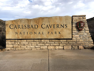
Very close to Guadalupe Mountains, technically still in the mountain range, is Carlsbad Caverns National Park. There is also a small amount of hiking in this national park but we focused on the caverns themselves.
Unlike Mammoth Caves, Carlsbad Caverns allows self guided tours of the natural entrance and the big room. Which was extra nice for us because entrance on those tours falls under the park entrance fee and is covered by our annual pass.


We opted to walk in the natural entrance into the big room and then take the elevator back up. This meant that we started by descending 750 feet along 1.25 miles into the cave. It was pretty steep, but mostly pretty wide. It also takes you by some pretty cool formations like the Boneyard.

The main attraction is the big room. The tour around the big room is another 1.25 miles but this time mostly very flat. There are tons of cave "decorations", or speleothems, around.


There was also some left over remnants of early cave explorers, who took this ladder 90 feet down into the lower cave. A prospect Kathleen found terrifying.

To get back up we took the elevator, which left from the "Rest Area and Lunchroom," an area of the cave that made us giggle. It was a complete plaza in the cave, with snacks and a gift shop that seemed super out of place.

They even had restrooms that looked like you were walking off into a deep cave tunnel,

but were actually quite nice.

The contrast here, made this part of the cave almost feel fake. More like a Disneyland cave than an actual cavern.
Throughout our tour we couldn't help comparing Carlsbad Caverns to Mammoth Cave. Overall, the Caverns are a lot more open. The big room is "mammoth" in a way Mammoth cave wasn't. The mammoth nature of Mammoth caves comes from the fact that they stretch 419 miles, more of which is still being discovered. But they can still feel very claustrophobic. The Big Room however is nearly 4,000 feet long, 625 feet wide and 255 feet high at its highest point. As long as you can get past the fact that you are 800 feet unground, its really quite hard to be claustrophobic. There are also tight parts of the Caverns that they take guided tours too, but we didn't end up taking one.
The Caverns have many more speleothems, and are much more "spectacular," but they also feel much more "developed." While large sections of both caves are lit, a trip with a ranger into Mammoth Cave feels much more like an exploration. They will turn off the lights at one point in the tour letting you see and hear what the caves are naturally like. Meanwhile there a paved paths and handrails throughout Carlsbad Caverns, and everyone is viewing at their own pace.
Both of the cave parks we've seen so far have been incredibly fascinating and gorgeous. And also very different and unique.
Friday, February 28, 2020
Guadalupe Mountains National Park

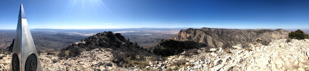
Our next park up was Guadalupe Mountains in the Northwestern area of Texas, on the boarder with New Mexico. This park has both a lot of opportunities to hike and a lot of history, and we got the opportunity to explore both.
On Thursday we started by doing some of the hiking. There were a ton of good hiking option but we settled on climbing up to see the highest point in Texas. We almost turned back because we were feeling a little under the weather but we're so glad we didn't. The 3,000 feet of elevation gain over 4.2 miles up the mountain were definitely strenuous. The trail was a little bit scary at times.

The view was worth fighting through the slight illness and fear.

Unfortunately Kathleen's shoes have decided they've had about enough of hiking.

On Friday, we explored the historic aspects of the park. We started with the Frijole Ranch Historical Museum. The museum is housed in an old ranch house that was built by some of the first white settlers in the area who came to ranch cattle. The house was later expanded by the Smith family who came and built an orchard. They also added a school house which doubled as a post office and community gathering area.


Inside the house they also have information about the Mescalero Apache who lived in the area and placed great significance on the mountains, including in their origin story. Nearby parts of the park also served the Butterfield stage coach in 1858. The stagecoach was the first constant form of overland communication linking St. Louis and San Fransisco in 1858 and only ran for 11 months before a safer route opened up to the south.
After learning some of the history we took a short walk up to Smith Spring up the hill.

We ended our exploration of the park up at McKittrick Canyon, which has been said to be the must beautiful spot in Texas. It was getting late in the day and we were pretty tired so we didn't do the full hike unto the canyon. Instead we contented ourselves with a shorter four mile out and back up the trail to just get a taste of it.


There is definitely a lot to see in this park as there were tons more hikes that we didn't do. We both thought that coming back to do a backcountry backpacking trip would be a lot of fun, unfortunately since Aiden isn't allowed on most national park trails, now wasn't the time. But we felt like we saw a good amount of the park, and would love to come back in the future.
Sunday, February 23, 2020
Big Bend National Park: Ross Maxwell Scenic Drive
 |
| Official NPS Map. Click and zoom in to enlarge for details. |
For our third and final day in the park we decided to take on the Ross Maxwell Scenic Drive. The drive is 30 miles total down to the Santa Elena Canyon, and there are a plethora of stops and hikes to check out along the way. Because one of the highlights of the park for some people is the Santa Elena Canyon, we decided to start by driving the whole length of the road and then stop on our way back up.

The Santa Elena canyon hike (red arrow on map) is fairly short but it a little tough, you start by finding your way across a river and then going up and over a rocky pass into the canyon. It is gorgeous though!

The high walls of the Canyon can really make you feel small.


Next we stopped at Dorgan House Trail (orange arrow on map), there was really hardly a hike here at all, mostly a walk out to the remnants of some old farm houses. We wanted to stop here because the ranger at the talk we attended in the Chisos Basin told us about the petrified wood fireplace. It was as cool as we hoped.


Next up was the Castolon Visitor Center (yellow arrow on map). There used to be a historic town in Castalon, however it burnt down in 2019 so they are currently operating out of a temporary structure. There wasn't a lot to see here, so we got our final stamp for the park and moved on.


The trail that we decided we were both the most excited about was the Chimneys Trails (green arrow on map). The trail connects 7 miles through the desert over to a non-paved road. However, the Chimneys themselves are 2.4 miles out and can the hike can be done as an out and back. The trail is relatively flat, but completely in direct sun light and seems like it would be brutal in the summer.

The Chimneys are very interesting rock structures sticking out of the desert. They were formed by magma seeping into cracks in other rock that has no eroded away, leaving only the mold of the cracks.


The reason we picked this hike though was the ancient Native American art at the base of the rocks.


The trail is also just a nice walk through the desert with great views of local flora and fauna.


After this hike we were pretty much ready to be done for the day. We stopped at the Lower Burro Mesa Pouroff trail (blue arrow on map) because it was short 1 mile out and back to get to the bottom of dry waterfall.


There is also a Upper Burro Mesa Pouroff trail that will get you to the top of the pouroff and looked very interesting. However that trail was longer, and we were starting to run out of time in the day. It is definitely on our list if we ever come back.
We made one last stop at the Sotol Vista (purple arrow) which looks out across the whole desert. It was lovely at dusk. Several people were setting up to watch the sunset, which promised to be beautiful, but we decided we wanted to keep moving and try to find our pullout before it got dark.

Overall it was a great day and a great way to finish up our time at Big Bend. We had big hopes for Big Bend and it didn't disappoint.

Subscribe to:
Posts (Atom)